| Salmonella | A family of pathogenic bacteria including S. typhi, and S. paratyphi-A, which gives rise to typhoid and paratyphoid fever. Other species can cause moderate to severe gastro-enteritis. Although Salmonella is mostly associated with food poisoning, it can also be transmitted through water. |
| Salvinia | (S. auriculata ). A troublesome floating tropical hydrophyte that spreads rapidly. For example, in only a few years, 500 km2 of Lake Kariba was covered in Salvinia. Consequences include the interception of light, water de-oxygenation, and the death of phytoplankton and fish. |
| sand | Rock particles in the size range 63 μm to 2.0 mm. 'Sand' does not have any compositional connotations. |
| sanding up | Sedimentation in the sump of a borehole. To compensate for this, bores often extend for several metres below the active screen. |
| sand trap/gate | = Sediment trap. A gated opening in a section of channel, with a large cross-sectional area. Sand traps are set up in experimental streams or irrigation channels to allow the medium-to-coarse sediment to settle out. |
| saprobicity | A measure of biodegradable organic matter in a stream. |
| sapropel | Gelatinous black sludge characteristic of anaerobic lake beds. |
| saqia | = Sakiya. An ancient mechanism of lifting water for irrigation. It consists of two enmeshed wheels with axes at right angles. The horizontal wheel is rotated by an ox, mule etc, and is used to drive a vertical wheel with numerous buckets. The lift is up to six metres. Two oxen can lift up to about 300 m3.hr-1. Saqias are still widely used in parts of India and the Nile Valley. |
| saturated zone | This is not defined as 'all parts of an aquifer in which the pores are 100% filled with water'. Rather, the s.z. is 'all parts of the aquifer in which the hydrostatic pressure is > atmospheric pressure'. In practise this is almost the same, but the capillary fringe is not included in the s.z., whilst there may be bubbles of air entrapped in the s.z., especially with a rising water table.
|
| saturation deficit | (1) At a given temperature and pressure, the additional moisture required to bring air to saturation, ie: ea- ed.
(2) The water depth, in mm, required to bring a soil surface to saturation (including maximum wetting of depression storage). However, saturation of the entire section to the water table is not necessarily implied. Since the wetting front is mobile, the soil saturation deficit is variable, and inadequately defined.
(3) In a solution, the saturation deficit is (Cs - C)/Cs where C is the solute concentration and Cs is the saturated concentration of the solute at the same temperature. |
| saturation index | (1) S.I. = log(IAP/K6), where the Ion Activity Product is a function of the actual solute concentration, and (or in alternative notation) is the equilibrium solubility constant. The three possibilities are: undersaturation if S.I. < 0, exact saturation if S.I. = 0, and supersaturation (= oversaturation) if S.I. > 0. Important : The saturation index is only meaningful in the case of equilibrium thermodynamic conditions.
(2) The Langelier Index (q.v.) is also sometimes referred to as the saturation index. This practice is confusing, and should be dropped. |
| savannah | Or savanna. Tropical grassland, often with scattered low phreatophytic trees, such as Acacias. |
| scald | An erosive depression in which topsoil is removed, and a crust develops at the previous topsoil - subsoil boundary. Most scalds are associated with dryland salinity, but sodic and non-saline scalds also occur. |
| SCC | Surface Contact Cover. Any soil surface cover, such as a mulch, leaf litter or low vegetation, which absorbs raindrop impact and erosion, and which inhibits runoff. |
| schistosomiasis | = Bilharzia. Various species of water snail are the intermediate hosts for this infectious parasitic fluke. Over two million people are infected throughout the tropics despite great efforts to eliminate the snail vector. Chemical control of the snail has largely succeeded in China and elsewhere, but increasing irrigation throughout the tropics and subtropics has also extended the range of the disease. |
| Schlumberger array | In shallow resistivity surveying, a symmetrical configuration of four electrodes in which the inner (potential) electrodes are much closer together than the outer (current) electrodes. Schlumberger, Wenner and 'offset-Wenner' are the most commonly used electrode configurations.
|
| Schoklitsch equation | An empirical expression for the critical discharge, , per unit width of channel.  , where γ = ρ.g, d6 is the sixth decile particle size, and S is the stream-bed gradient. This equation works reasonably well for coarse high-energy sediments. Like all empirical equations, the Schoklitsch equation does not address the physics of the sediment transport problem, and is therefore of variable success. , where γ = ρ.g, d6 is the sixth decile particle size, and S is the stream-bed gradient. This equation works reasonably well for coarse high-energy sediments. Like all empirical equations, the Schoklitsch equation does not address the physics of the sediment transport problem, and is therefore of variable success. |
| Schoeller diagram | A visually chaotic and clumsy nomographic diagram of a water chemistry; best consigned to the trash-can of history. |
| Scoby's formula | ...for flow in pipes:  , where C is a friction constant, V is the velocity and d is the pipe's internal diameter. , where C is a friction constant, V is the velocity and d is the pipe's internal diameter. |
| Scotch mist | = Mizzle. Precipitation in the form of ground level advection of cloud droplets |
.
| scour | Stream bed erosion by fast flowing water. The processes are surprisingly complex and difficult to simulate. Contributing variables include density, particle size and distribution, armouring, sediment supply, velocity and turbulence, and the opposing processes of erosion and deposition. Most rivers are in a state of quasi-equilibrium between particle mobilisation and deposition (except during floods). Thus, if the suspended sediment concentration is reduced, as downstream from a dam, then the scour rate is dramatically increased until a new equilibrium is found. |
| screen | That part of a borehole consisting of a slotted tube or wire- wound tubular frame which permits the inflow of groundwater to the well whilst maintaining the structural integrity of the well. Naturally, the 'slot size' depends upon the particle size of the aquifer so that water is admitted whilst sand particles are not. Much of the skill in well logging is devoted to setting the screen at the most appropriate depth. |
| screw pump | See Archimedian screw. |
| S - curve | A graph of the 'cumulative time unit hydrograph'. This hydrograph results from indefinite continuous rainfall of intensity 1/T mm.h-1. It is used to calculate unit hydrographs of differing duration. |
| sealed source | Any source of radiation that is completely enclosed in its container. Therefore, radiation can escape, but the source material cannot. |
| sealing | Soil surfaces subjected to continued infiltration tend to 'self-seal'. The soil physics involved is complex, and is still not fully researched. Sealing in unlined irrigation ditches is of economic importance, and may be mediated by microbiota. |
| Secchi disk | A disk marked in black and white quadrants, which is lowered into turbid water until it can barely be seen. The resulting depth is a measure of the turbidity. |
| secondary baseflow | See interflow.
|
| secondary flow | Components of flow perpendicular to the main direction of flow. eg. helicoidal flow, or contraction immediately upstream of non-suppressed weirs. |
| secondary porosity | (As opposed to primary or intergranular porosity). Any porosity that develops after deposition, especially due to tectonic or dissolution processes. Most secondary porosity is strongly anisotropic such as faults, joints, bedding planes, shrinkage voids, and karstic development. |
| secondary treatment | A range of mostly biological processes, by which filtered sewage or other wastewater is cleansed. Secondary treatment should remove most, if not all, of the organics (and hence the BOD), together with any residual particulate matter. For high quality re-used water, tertiary treatment may still be required. |
| secondary salinisation | Human induced salinisation. |
| section control | = Complete control. Streamflow conditions in which stage is uniquely related to discharge. For example, immediately up-stream of a transition from subcritical to supercritical flow. |
| sediment delivery ratio | The ratio of sediment yield to total erosion in a catchment; the proportion of eroded material removed from a catchment by fluvial transport. |
| sediment discharge curve | = Sediment runoff curve. A graph of stage vs sediment load. The graph is different for rising and falling stages. |
| sediment hydrograph | A graph of fluvial sedimentary flux (both bed load and suspended load) vs time. |
| sediment load | The weight percent of a stream which is transported sediment. It normally varies up to about 1%, but rivers in loess or glacial areas may have exceptional sediment loads of up to about 5%. |
| sediment sump | = Rat hole = tail pipe. Casing below the screen used as a fine-grained sediment trap. |
| sediment yield | ...of a catchment...The bed load and suspended load of a river, usually quoted on a mean annual basis. |
| seeding | See cloud seeding. |
| seepage | Diffused groundwater emergence at the surface, as opposed to a spring (point emergence). |
| seepage face | The areal extent of Darcian flow exposed at the surface or in a mining / foundation operation. |
| seepage velocity | = Darcian velocity ÷ porosity. The true mean rate of ground-water flow around particles in the aquifer. Seepage velocity is always > the Darcian velocity. |
| seep zone | Saturated soil near the base of a slope, where interflow and groundwater flow emerge to become surface flow. |
| segregated ice | The migration of pore water to a freezing front, resulting in frozen soil - ice with a planar texture. |
| seiche | = Gravity wave. A feature of lakes in which a hydraulic gradient set up by wind friction subsequently oscillates with a natural period, t, of:  , where n is an integer (normally 1, but possibly more if the lake geometry allows more than one nodal axis), l is the maximum fetch of the lake, and m the mean depth. The period typically varies from a minute to several hours. For a lake of several kilometres in length, a typical seiching amplitude would be about 10 cm, but seiching of over a metre in amplitude can occur on large lakes. cf. period of oscillation. , where n is an integer (normally 1, but possibly more if the lake geometry allows more than one nodal axis), l is the maximum fetch of the lake, and m the mean depth. The period typically varies from a minute to several hours. For a lake of several kilometres in length, a typical seiching amplitude would be about 10 cm, but seiching of over a metre in amplitude can occur on large lakes. cf. period of oscillation. |
| selectivity series | Different ions have varying degrees of affinity for adsorption at an exchange site (due to differing charge densities). Ranking of this affinity is somewhat variable, but may be approximated by the selectivity series: Ba2 +>Sr2+>Ca2+>Mg2+(divalent), and Cs+>Rb+>NH4+>K+>H+>Na+>Li+ (monovalent). |
| selenium | (Se) A teratogenic element with a chemistry somewhat similar to sulphur. Large concentrations of Se are immobilised in reducing environments such as coal, sulphides and marine shales, but when oxidised, much more soluble species, such as SeO32-, and HSeO3- (selenite and biselenite) are mobilised. Several major aquifers in the western USA and elsewhere are currently suffering increasing Se pollution due to large drawdowns which create new oxidising unsaturated zones from which biselenite is reached. |
| self potential | = Spontaneous potential. A geophysical technique in which natural variations in electrical potential are measured between surface points or between the surface and successive depths of a borehole (the bore being filled with a conducting drilling fluid). In boreholes the SP log is normally run in conjunction with the resistivity log. |
| semi-aridity | There are so many connotations in the literature that no definitive entry is possible. Broadly, any climate with a perennial monthly moisture deficit of between -20 and -40 mm is considered semi-arid. |
| semi-confined | An aquifer is semi-confined if pressure release (by pumping) induces significant leakage from one or both bounding aquitards, and if flow in the aquifer is essentially horizontal whilst leakage into the aquifer is essentially vertical. If leakage through an aquitard also has a significant horizontal component, then the aquifer is semi-unconfined. |
| semi-variogram | The basic tool of geostatistics. A graph of variance vs inter-sample distance. |
| senility | The final stages of a mature river, characterised by sluggish flow, barely above the base level of erosion, and meandering through a wide, very low-relief floodplain. |
| sensitivity | (1)...of a measuring instrument...The rate of change of measurement with concentration: dx/dC.
(2)...of a soil... The ratio of soil strength (shear strength) in the natural undisturbed (field) state, to its strength under disturbed (laboratory) conditions at the same moisture content. Pre-consolidation reduces the sensitivity of a clay, whilst a high water content and / or a liquidity index of >1 increases the sensitivity. The classification is:
| insensitive clays | <1 |
| low-sensitivity clays | 1-2 |
| medium-sensitivity clays | 2-4 |
| sensitive clays | 4-8 |
| extra-sensitive clays | >8 |
| quickclays | >16 |
Most soil sensitivities are between 0.9 and 1.0. cf. quickclays. |
| separation | (1) Separation occurs at a discontinuity of streamlines, or at a discontinuity between laminar and turbulent flow.
(2) Bubble separation, or 'cavitation', when the velocity head falls below the vapour pressure.
(3) A curling trace of vortices caused by separation of a boundary layer from a solid surface. |
| service level | A subjective measure of convenience and accessibility of sanitation and water supply; especially used in the planning of resources in developing countries. |
| set casing | To install casing. |
| set up | Wind set up on a lake is the process by which wind shear pushes water to the downwind end of a lake, thereby creating a non-horizontal surface. Release of the wind shear results in a damped harmonic oscillation of the lake levels from one end to the other. |
| sewage | Liquid and solid excreta. The main source of urban pollution of surface and groundwaters. The pollutants are mainly micro-organisms (innocuous and pathogenic), phosphates, nitrates, and organic nutrients. |
| sewerage | The piped system by which sewage is transported to a treatment or disposal site. |
| shaduf | (Arabic). A cantilever-bailed well (bucket and counterweight), suitable for small water supplies from a shallow water table. |
| shakehole | A doline which displays collapse features, characteristic of very advanced karstic development. |
| shale | One of the most common types of sedimentary rock, primarily consisting of clay minerals. Prolonged compression has squeezed out most, if not all, of the water, and has imparted a distinct planar fabric to the rock texture. Shale is invariably an aquiclude or aquitard. |
| shale line | = Shale base line, = clay line. The reference line on an S.P. borehole log, defined by the 100% clay signal. In theory, it should be a vertical line, but it may shift slightly due to stray ground, salinity and system potentials. |
| shale shaker | Equipment on a rotary drilling rig for separating the cuttings from the drilling fluid. |
| shallow karst | A karstic aquifer which is entirely higher than the outflow point. Note that 'shallow karst' is unrelated to either aquifer thickness or depth to the phreatic surface. |
| shear zone | An imbricate, or brecciated concentration of fracture planes, often forming a locally high-yielding planar aquifer. |
| sheet flow | A thin sheet of water typically in the order of a mm in depth, flowing at the land surface, especially over bare rocks. It occurs only when the rainfall intensity > infiltration rate, and when all surface storage has been filled. Sheet flow conditions approximate to Hortonian conditions types 2 and 3. |
| sheet piling | Interlocking strips of steel driven into unconsolidated ground to form either an impervious screen, or to prevent slumping of surface / near-surface sediments. They may be temporary, as in foundation, quarrying or land-fill operations, or permanent. |
| shields | ... such as Nipher, Tretyakov and Alter shields. Various devices designed to deflect or absorb micro-aerodynamic turbulence around the rim of a precipitation gauge, thus giving more accurate measurement. |
| Shields diagram | A log-log plot of dimensionless shear stress, Ψ , vs the boundary Reynolds number. The upper field of the diagram indicates particle erosion and transport, whilst the lower indicates stream bed sedimentation. The diagram is best suited to fine or medium particle sizes. NB: the boundary Reynolds number is: v.d/ν , where v is the fluid velocity, d is the mean particle diameter, and ν is the kinematic viscosity. 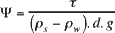 , where τ is the bed shear stress, and ρ is the density (of sediment or water). , where τ is the bed shear stress, and ρ is the density (of sediment or water). |
| Shigella | Shigella is the most common aquatic bacterial pathogen, and can infect from very low levels of contamination. Fortunately, it survives poorly in water; typically for 0.5 to 4 hours in warm water. S. disenteriae and S. flexneri are the sources of bacillic dysentery. Other strains cause mild diarrhoea. |
| shoal | A shallow submerged sandbank in a river or lake (or sea). |
| short normal | A 16 inch resistivity probe used in borehole logging, which gives good spatial resolution, but poor accuracy. cf. long normal.
|
| shoulder ditch | A ditch dug along the top edge of a slope to prevent erosion. |
| shrinkage limit | The water required to completely saturate the pores of an oven-dried soil or sediment, expressed as weight % of the dry sample. The weight equivalent of effective porosity (vol/vol). |
| side contraction | The reduction in width of a stream as it flows over a sharp-crested weir. It is mainly caused by components of flow perpendicular to the main flow direction. See suppression. |
| sieve analysis | ≈ Particle size analysis. A graph of cumulative percentage retained (in a nest of sieves) vs particle size (sieve mesh size), for any uncemented sediment. The % passing is plotted against grain size represented by each sieve to yield as 'S' shaped graph. A steep curve indicates a well-sorted sediment, whereas a shallow curve is obtained from a heterogeneous sediment. Such analyses are needed for sediment transport analysis, and for the estimation of optimum screen size and gravel pack size in a borehole.
| % passing | 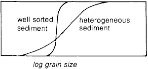 |
|
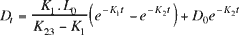 where K1 and K2 are reaction rate constants for deoxygenation and re-aeration respectively, Do and Dt are the dissolved oxygen deficits (initial and after time t), and Lo is the initial biological oxygen deficiency.
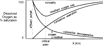
 ... (Eq. 1)
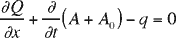
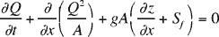 ...(Eq. 2) , where Q is the mean discharge in the direction of flow, t is the time, x is the distance in the direction of flow, z is the depth of flow, g is the gravitational acceleration, Sf is the friction gradient, A is the active cross-sectional area of flow, A0 is the cross-sectional area of off-channel storage (such as overbank flow, or underflow in the bed sediments), and q is the nett inflow (+) or outflow (-) per unit distance of flow. There are several variations on these equations. For example the second term of Equation 2 may be modified by α, (the velocity head coefficient) if α is not ≈1.0; whilst the third term may include additional 'S' factors to model channel expansion or contraction, or any non-Newtonian fluid behaviour (as in mudflows). Also a fourth term may be added to allow for the momentum of lateral inflows. In Equation 1, the second term may be modified by a 'sinuosity coefficient' to account for helicoidal flow. In both (Eq. 1) and (Eq. 2) the ∂/∂t... term is the 'unsteadiness', without which the equations revert to the simpler and generally more familiar steady-state equations of flow. The second Saint Venant equation is very difficult to solve analytically, but software is available for numerical approximations.